Impressive Flood Control Plan
 |
| The maker showing the river levels in previous floods including the 1997 record breaker |
Flood control is something John and I find interesting. We lived in a city, Cedar Rapids IA, that was ravaged by flood in 2008. In the 3 years since then we watched as the city has tried to recover and make a plan for the future. I know that they had a group come here to Grand Forks to look at their flood control measures and why they didn’t learn more and take more of these plans back to CR, I really don’t know. As a tax payer in CR we were very frustrated when we saw the city rebuild its City Hall in the middle of the river, literally, on May’s Island. There was such an opportunity there to change the landscape in a way that may have prevented future flood damage but my opinion is they put their heads in the sand and are sure it will never happen again.
 |
| Some of the flood wall along the bike trail |
 |
| Earthen levees line other portions of the trail |
Here in Grand Forks and East Grand Forks, a different approach was taken. In 1997 this area had a flood that was devastating. It took out neighborhoods and buildings much like what happened to us in Cedar Rapids, probably worse. Instead of putting everything back where it was they developed a long term extensive plan to protect their cities. When you come to these cities there now is the Greater Grand Forks Greenway that is green space on either side of the river. In this green space are parks, bike trails, a campground & golf courses that has enhanced the beauty of their river and their towns. Outside that area are earthen levees and flood walls both done in a way that does not detract from the beauty of the river.
 |
| One of the trail heads, Eagle Point. |
In April of this year all that planning was put to the test as the Red River once again experienced a major flood. In 1997 the river crested at 54 feet, this year at just over 49 feet. I found a time lapse on Youtube, that shows the flood marker and how close it came to the 1997 level. I found other photos out there with all the flood walls in place, there are sections that come in and out as necessary. These measures stood the test and protected the cities from the type of damage they experienced in that 1997 flood. There was a lot of expense and planning to get all these measures accomplished and in place but kudos to a city that made hard decisions and made their city a better place. I talked with one gentleman on the bike trail this week that felt that these cities have made themselves a better place for all their citizens after that flood. It meant sacrificing neighborhoods that once existed next to the river and backing all the development out a ways from the river bank but they gained wonderful green space for all to enjoy and a buffer zone to protect them all.
 |
| The Red River still running high in August |
There have been so many areas devastated by floods in the past few years. My personal feeling is some of it is due to things man has done to try to control the rivers. We continue to build dams and levees to try to control the water flow and when it backfires someone’s town downstream is underwater. We continue to build right on the banks and are surprised when the river rises and buildings go under. We continue to put down surfaces that instead of letting rain water seep into the ground when it rains instead runs into our sewers and runoff systems that empty into our rivers. I think we need to give our rivers some breathing room, enhance all of our lives with some green space. There are things we cannot control like snowfall amounts and its run off in the spring, rainfall amounts, hurricanes and all manner of things that Mother Nature has in store but we can try to respect the power of these things and try to build and live in such a way that we can recover easier. I think that is what the Grand Forks area has done right. I only wish Cedar Rapids had done the same when they had the chance. I know they are incorporating a few of these ideas but from what I could see they still do not have a comprehensive plan.
 |
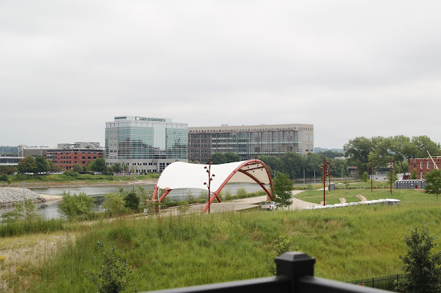
| A view of Grand Forks from the bridge |
I hope you all get to visit this area. The campground sits right downtown East Grand Forks, on the Minnesota side in what was once a local neighborhood. They are beautiful cities that have lots of great things to offer.
Happy Trails.........

What a great, insightful post. I agree that we do need to learn to respect Mother Nature much more than we do.
ReplyDeleteGood post. Here in the San Francisco Bay area we have a huge delta extending many miles inland to Sacramento. All there ever is is "talk" about delta improvements.
ReplyDeleteNow they want to build a bullet train down to LA. How much better it would be for the are to spend the money on flood control planning.
The time laspe video is great. It's hard to believe that the water can rise that much. We can never understand why so many places are built so close to rivers. You are always taking a chance that a flood could happen. I like what Grand Forks has done to try to prevent damage from another flood.
ReplyDeleteKevin and Ruth
www.travelwithkevinandruth.com